
directions
|
directions |
|
|
|
|
|
|
|
|
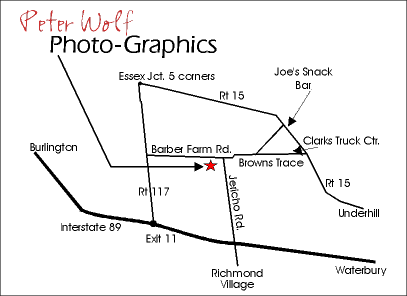 From Burlington (and north) take 89 south (or Rt. 2 to Rt.117) to exit 11, take a left off the exit ramp, under the interstate past the entrance ramp then take a right on to Rt. 117, go 2.5 miles and take a right on to Barber Farm Rd. go 2.4 miles to PWPG (sign at top of driveway) on right, across from cemetery. If you get to the intersection with Browns Trace you have gone too far. From Waterbury (and south) take 89 north (or Rt. 2 to Rt.117) to exit 11, take a right off the exit ramp, and an immediate right on to Rt. 117, go 2.5 miles and take a right on to Barber Farm Rd. go 2.4 miles to PWPG (sign at top of driveway) on right, across from cemetery. If you get to the intersection with Browns Trace you have gone too far.
From Rt.15 Cambridge/Jeffersonville area take Rt. 15 thru Underhill, take a left at Clark's Truck Center (Time & Temp sign @ corner) on to Browns Trace, go past high school straight thru stop, up hill, thru Jericho Center go straight on to Barber Farm Rd (don't take curve to left towards Richmond) PWPG is first drive on left (sign at top of driveway) across from cemetery.
From Richmond take Jericho Rd at lights which turns in to Browns Trace approx. 4-5 miles to Barber Farm Rd. on left at sharp curve entering Jericho Center. PWPG is first drive on left (sign at top of driveway) across from cemetery. |
|---|
© 1999-2005 Peter Wolf